When the Waves Turn the Minutes to Hours:1
Forces Behind Shipwrecks in the Port of Toronto
Will Sinodis
Toronto - 2023
Introduction
The legend and myth behind shipwrecks may seem like a distant event to people from the Midwest and Great Lakes area, more specifically, Torontonians. When one thinks of shipwrecks most people think of the legends of the Titanic or the Lusitania. In the Great Lakes area, the wreck of the Edmund Fitzgerald made infamous by the song of the same name, is arguably the only well-known wreck of the Great Lakes.2 However, as unexpected as it seems, Toronto has several shipwrecks that can be found when looking at its local history. This paper will explore the history of these shipwrecks in more detail by arguing that the causation of shipwrecks and their loss at the Port of Toronto were impacted by both geographical challenges along with human impacts. This will be demonstrated by examining specific wrecks that occurred at the port. This study will provide an overview on what caused these shipwrecks and illustrate the historic challenges for shipping on the Great Lakes and more specifically, Toronto.
Geographical Challenges of the Port of Toronto
The Port of Toronto is located at the base of the Toronto downtown core with the Western Channel and Billy Bishop Airport making up the western portion and the Eastern Channel, Leslie Spit and the port lands making up the eastern portion (See figure 2). To the south of the inner harbour sits the Toronto Islands (See figure 2). With the presence of the islands, we can see the first major geographical challenge to shipping, as the islands create a wall blocking access for ships trying to reach Toronto’s inner harbor. The islands, since the founding of Toronto (previously York), were seen as a challenge for naval activities and used to defend the harbour against possible invaders. In Historic Fort York, 1793-1993 Benn mentions that Lord Simcoe wanted to create a defendable area in the late 18th century that would protect Upper Canada from the Americans. He chose Toronto as it had a good connection with the rest of Upper Canada and it was easily defendable due to the presence of the islands, acting as a barrier for ships. On the north side of the Western Channel, Simcoe ordered the construction of Fort York and on the island side, at Gibraltar’s point, he wanted to construct a blockhouse where soldiers could safely bombard the enemy fleet (see. figure 1).3 Lord Simcoe choosing to construct a defensive position at Toronto and using the Western Channel as a choke point, demonstrates the physical Geographical challenges Toronto has for ships entering its harbour.4
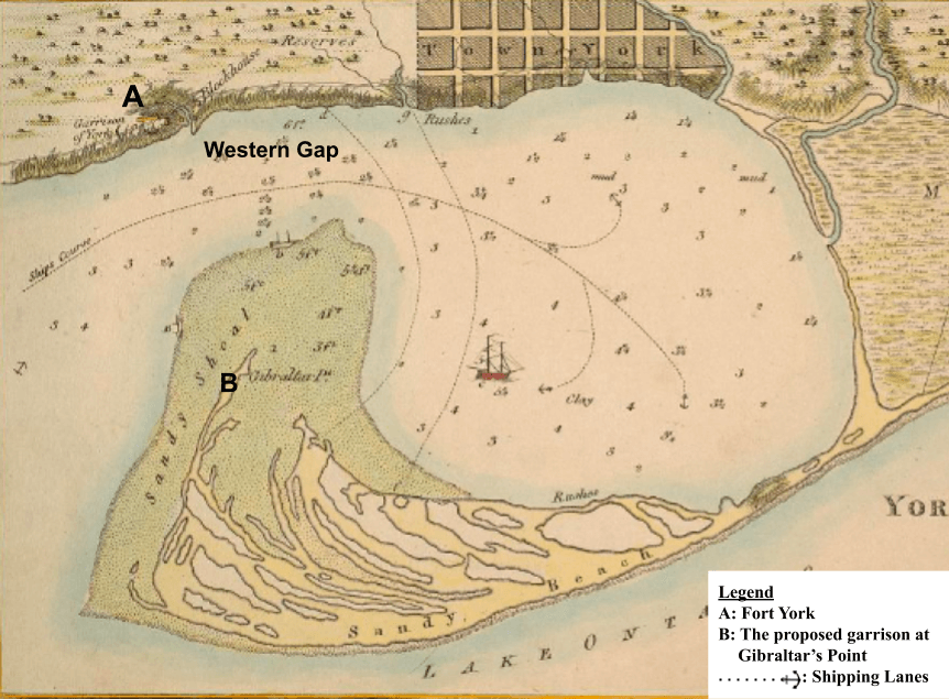

The two channels of entry have historically made navigating Toronto’s port especially challenging. When Toronto was originally founded, the Western Channel was the only means of entry to the harbour. This channel was 1,500 feet wide and 20 feet to 30 feet deep, but this entry was made difficult due to a sandy shoal at the bottom of the channel (See figure 2).5 Only in 1858 did a storm make an Eastern Channel navigable, however constant maintenance had to be carried out to maintain this point of entry, notably constant dredging was needed to keep this waterway open and protected from weather. In order to mitigate the challenges presented by the harbour Gibraltar’s Point lighthouse had to be constructed to aid ships entering the harbour and avoid running into the islands.6 The use of Toronto as a defensive position with its narrow entrance and difficult points of entry (see figure 1&2) demonstrates how these physical geographical features made maritime travel challenging and ultimately led to shipwrecks.
Furthermore, the environmental geography of Toronto was also a major factor in maritime transportation. The article, The Value of Weather Information Services for Nineteenth-Century Great Lakes, mentions the impacts that weather had on shipwrecks in the Great Lakes Region. Here Craft mentioned that shipwrecks were so abundant that in 1868 and 1869 there was a \$2.7 million (1880’s dollars) or \$80 million (2023) that resulted from shipwrecks on the Great Lakes.7 These wrecks were mainly due to the weather and stormy condition on the lakes. These conditions are why the US government created the Weather Bureau, to protect and warn ships of poor weather conditions.8 In Camu’s article he agrees with this saying,
“Knowing that it is impossible to contain the forces of nature, … of the St. Lawrence/Great Lakes waterway, … it seems that the authorities had no choice but to improve navigational aids, to enforce stricter regulations and to better inform users about dangers.”9
He supports this statement by demonstrating that weather related shipwrecks made up 56.3% of shipwrecks in 1868-85 and 60.7% of shipwrecks between 1886-1900.10 These weather-related disasters were so prevalent in Toronto that in the 1870s Toronto established a central warning station to receive and send weather related warnings to protect shipping traffic in the port.11 These poor weather conditions were very prevalent on the Great Lakes, and more specifically in Toronto and thus demonstrates that environmental geography, such as weather, was a major factor in shipwrecks on the Great Lakes and in places such as the Port of Toronto.
Human Impact
In addition to Toronto’s challenging physical and environmental geography for shipping, human factors on shipping also had a major impact and contribution to maritime accidents. The first human factor that contributed to shipping accidents is the large amount of traffic in Toronto. This often led to ships running aground or even colliding. Camu (1996) says that,
“… the largest numbers of losses were directly related to the frequency of traffic in major shipping lanes on the lakes or at the entrance to ports and harbours. In Lake Ontario, … the approaches to Toronto … were prone to mishaps.”12
This traffic was likely attributed to the large amounts of trade going into Toronto. Kerr and Spelt (1956) mentioned that Toronto was the most important port on Lake Ontario.13 When looking at the Toronto Board of Trade reports for 1882-83 this high traffic in the Toronto harbour can be seen. On average, the port was exporting \$300,000 (in 1882-82 dollars) between the years of 1882-83 which would be roughly \$9,000,000 in today’s dollars and importing on average approximately \$1,000,000 (in 1882-82 dollars) per month which would be around \$30,000,000 in today’s currency.14 This demonstrates the importance of the Port of Toronto and also shows that this port was incredibly busy which would create major traffic in the cities narrow shipping lanes, contributing to several accidents and wrecks, as previously mentioned. Accidents caused by high traffic is a strong demonstration of man’s impacts on shipwrecks in Toronto.
In addition to high traffic in the Port of Toronto, the human error relating to neglect and safety malfunctions were also a major cause of shipwrecks in Toronto. To this day, it is often found that neglecting safety practices leads to disasters in shipping. This was no different in the past. These incidences were common in the second half of the 19th century. Camu said that safety errors such as equipment malfunctions made up roughly 19% of all shipwrecks on the Great Lakes.15 This demonstrates that shipwrecks were also impacted and caused by malfunctions on shipping machinery. Now that it has been demonstrated how both geographical impacts and human errors cause shipwrecks in abundance, this essay will explore various cases of how one or more of these factors caused shipwrecks in the Port of Toronto.
The Monarch and J.G. Beard
The first two wrecks to be examined are the Monarch and J.G. Beard. The Monarch was a newly constructed steamer built in Sorel, Quebec in 1856 and she was owned by the A. & D. Shaw & Co. company (see figure 4).16 She was designed to carry cargo such as fish and sugar. This is what she was carrying at the time of her wreck.17 Like the Monarch, the J.G Beard was also constructed in 1856 and thus a very new ship, however she, unlike the Monarch was a schooner.18 She was constructed in Oakville and owned by J.G Beard a coal merchant.19 This schooner would typically carry coal for J.G Beard around the Great Lakes, mostly in the Golden Horseshoe area.20
On November 29th, 1856, the Monarch was arriving to the Western gap coming back from Montreal with 249 tons of merchandise.21 It was 5am and according to news reports that day, the gale on the lake was very strong.22 This caused the Monarch to run aground on the south side of the islands unable to navigate around the peninsula, due to wind (see figure 3 & image 1).23 The main culprit of this wreck was the geography of Toronto. Firstly, the Monarch was unable to traverse the challenging obstacle the Toronto Islands presented and an awful storm, all too familiar to Toronto, eventually caused the Monarch to crash into these Islands. This demonstrates that the physical and environmental geography of Toronto contributed to this wreck.
To make matters worse the J.G Beard just a few days later ran aground and wrecked on the 2nd of December 1856 as she confused the Monarch’s light, for the light of Gibraltar’s lighthouse (see figure 3).24 Like the Monarch, the J.G Beard also fell victim to the challenging geography of Toronto and the storm as it ran aground on the island as it mistook the Monarch’s light with Gibraltar’s lighthouse. Human error also contributed to this wreck, due to the captain’s poor navigational skills and inability to recognize the light of the Monarch from the lighthouse. Additionally, J.G Beard wrecking due to another ship, demonstrates how the human impact of heavy traffic in Toronto can cause wrecks. Thus, these two wrecks illustrate that human error and geography can impact wrecks.

The Resolute
The Resolute was another ship that fell victim to the challenging geography of the Toronto harbour. The steamship Resolute was built in 1883 and owned by the Deseronto Navigation Company constructed for the lumber trade. However, she would carry many materials, such as coal, brick, and other construction materials (see figure 4 & image 2).25 She was rebuilt several times to increase her size and carrying capacity.26 When in possession of Michael J. Haney and Roger Miller, she often traded in Toronto and often was used to tow many of the companies barges in the harbour.27 When towing one of these barges the Resolute wrecked.
On November 21st, 1906, the Resolute was leaking heavily from the rough gale of the Lake. She was tasked to tow in the wooden schooner-barge P.B Locke into port.28 The P.B Locke was carrying coal for Michael J. Haney and Roger Miller, Proprietors. The two ships met at the Eastern gap near the modern Leslie Spit. She did not have enough power due to her leak to navigate through the Eastern channel (see figure 2), so she towed her barge, who was also leaking, around the islands to the Western Channel (see figure 2). She dropped anchor near the modern Hanlan’s Point beach. However, due to the leaks of both her and the P.B Locke, she did not have enough power to navigate through the Western Channel. She made another run around the islands to Eastern Channel before going back again due to her lack of power and anchored again near modern Hanlan’s Point beach.29 The weather deteriorated rapidly resulting in the leak becoming out of control, which resulted in the captain ordering to abandon ship. The Resolute eventually sank outside the Western Channel (see figure 3).30 Again, we can see the geography of the Toronto harbour contributing to another wreck. Firstly, a gale caused the Resolute to spring-a-leak, is an example of environmental geography, contributing to this wreck. The physical geography of the islands blocking entry of the harbour also impacted this sinking, as the Resolute did not have enough power to navigate the challenging port and eventually sunk due to this. It is also important to note that the Resolute at this time was very old and reconstructed several times before being purchased by Haney and Miller. Thus, the human factor of not taking precautions despite the age and wear of the Resolute likely played a role in her sinking. Therefore, the rough environmental and physical geography of the port along with the lack of caution by Haney and Miller, in relation to the wear and age of the Resolute contributed to the sinking of the Resolute.


The Sligo
The Sligo was launched at the Shickluna Shipyard at St. Catharines in 1860, and later rebuilt in 1874 (see image 3). 31 She was tasked with carrying cargo such as barley, coal, coal oil, corn, earthenware, flour, railroad iron, salt, stone, timber, and wheat among other products, all over the Great Lakes.32 Eventually, she was rebuilt and converted into a steam-barge in 1909 and like the Resolute she was owned and operated by Michael J. Haney and Roger Miller, Proprietors.33 During this time, she was tasked with transporting materials for the construction of Highway 2 between Toronto and Hamilton. During this time the Sligo would meet her end.
The Sligo eventually wrecked in the Port of Toronto. According to Monk on September 5th, 1918, as the Sligo was being towed into the Port of Toronto, by the City of New York. A leak in the City of New York was discovered and forced the crew to cut the towline between the two ships. On this day there was a very bad storm, on the lake. The Sligo was now stranded and started to take on seven feet of water.34 The crew attempted to pump the water out however their efforts were in vain as the Sligo’s level was lowering. This was a result of carrying heavy stones, which eventually led the crew to abandon her, leading the ship to sink (see figure 4).35 This sinking again demonstrates how geography and human error were a major factor in causing shipwrecks. If the captain was more aware of the leak in the City of New York, the Sligo could have been saved. Additionally, much like the Resolute, Haney and Miller were operating her despite her age and the wear she likely took on over the year. This likely contributed to her wreck. The high traffic and abundance of products moving into Toronto also played a role in this sinking as the Sligo’s overloaded stone cargo along with her aging body resulted in her being left stranded in the Port. Furthermore, the Sligo would have not taken on so much water if it was not for the storm that is all too familiar to Toronto. Therefore, the poor maintenance of the City of New York, the age and wear of the Sligo, her heavy load of cargo and the heavy storm, all caused the Sligo to sink. This demonstrates that the Sligo’s sinking was caused by both human error and poor weather conditions.

| Name of Ships | Place of Construction | Year of Construction | Ship type | Date of Wreck | Causes of Wreck | Cargo During Wreck |
|---|---|---|---|---|---|---|
| The Sligo | St. Catharines, ON36 | 1860 as Prince of Wales37; 1874 as Sligo38 | Schooner39 | Sept 5th, 1918 40 | Stranded in the Water and lowering water levels due to rain and heavy cargo 41 | Stone42 |
| The Monarch | Sorel, QB 43 | 185644 | Steamer 45 | Nov 29th, 1856 46 | Sole and heavy storm causing ship to run aground47 | Sugar and Fish48 |
| The J.G Beard | Oakville, ON 49 | 185650 | Schooner51 | Dec 2nd, 185652 | Navigational error confusing Monarch’s light with light causing ship to run aground 53 | Coal 54 |
| The Resolute | Deseronto, ON55 | 188356 | Steamer 57 | Nov 21st, 1906 58 | Leak in hull caused Storm59 | Towing barge P.B Locke full of Coal 60 |
Figure 4: This is a collection of general information on the four ships assessed in this essay, including Place of Construction, Year of Construction, Ship Type, Date of Wreck, Cause of Wreck, and the Cargo of these Ships.
Conclusion; Legacy and Warnings for Mariners in Toronto
In conclusion, both geographical challenges and human factors impacted the sinking of the Sligo, Monarch, J.G. Beard, and Resolute. This provides an insight into why shipwrecks in the past have occurred, notably in Toronto. With this, it is important to look at how tragedies like these can be prevented. Thankfully, technology has significantly improved since the time of these shipwrecks. Ships are much safer and wrecks, especially in Toronto, are almost non-existent. Ships are less likely to spring-leaks and fall victim to weather, due to the improved technology. Also, modern regulations for training crew in the event of an accident has ensured that shipwrecks are less likely.
The importance of maritime law and safety procedures to prevent these wrecks remains important today. Even with improved ships and technology, wrecks still happen in Toronto. On June 12th, 2021, a water taxi, transporting people between the islands and the city was speeding, eventually the boat took on a foot of water and was listing to the bow. Although the boat did not sink, this demonstrates how modern ships are not immune to wrecks, despite modern technologies.61 This shows that although shipping today is more regulated, modern vessels can still suffer the same fates as the Sligo, the Monarch, the J.G Beard, and the Resolute, if regulations are not followed.


These wrecks are mostly lost to the public mind of most Torontonians; however, the legacy of these ships live on. The Sligo is still at the bottom of the lake and is often visited by divers (see image 4).62 Similarly, although the Monarch was towed away a few weeks after her wreck, pieces of her, almost 170 years after she wrecked, are still found on the island today (see image 5).63 These subtle reminders of these wrecks, provide any who come across them, with a warning of the dangers of the waters of Toronto.
Acknowledgments
Some of this collective research along with important advice was provided to me by Dr. Kimberly Monk of Brock University. I would like to thank her for directing me to various works including her master’s thesis: A Great Lakes Vessel Type: Archaeological and Historical Examinations of the Welland Sailing Canal Ship, Sligo, Toronto, Ontario. This along with other forms of information helped to me to articulate a full story and argument on the topic of shipwrecks in Toronto.
-
Gordon Lightfoot. 1976. "The Wreck of the Edmund Fitzgerald" Side 1, Track 2, on Summertime Dream. Reprise Records. ↩
-
Gordon Lightfoot. 1976. “The Wreck of the Edmund Fitzgerald.” ↩
-
Figure 1: Map of the old Port of Toronto, created in 1814. Adapted from Joseph Bouchette, “Plan of York Harbour”, Toronto Public Library Archive, 1814. https://digitalarchive.tpl.ca/objects/247625/. Along with information from Carl Benn and Henry N.R. Jackman. Historic Fort York, 1793-1993. Toronto: Natural Heritage/Natural History, Incorporated, 1993, 21-25. ↩
-
Benn and Jackman, Historic Fort York, 1793-1993, 21-25. ↩
-
Figure 2: Map of the Modern port with two Channels. Adapted from Gene Desfor and Lucian Vesalon, “Urban Expansion and Industrial Nature: A Political Ecology of Toronto’s Port Industrial District.” International journal of urban and regional research 32, no. 3 (2008): 586–603; Donald Kerr and Jacob Spelt, “Overseas Trade at the Port of Toronto.” The Canadian geographer 2, no. 8 (1956): 1. ↩
-
Walter Lewis, “Lighthouses in Upper Canada, 1803 - 1840.” The Northern mariner 28, no. 1 (2018): 7-8. https://tnm.journals.yorku.ca/index.php/default/article/view/221/207 ↩
-
Erik D. Craft, “The Value of Weather Information Services for Nineteenth-Century Great Lakes Shipping.” The American economic review 88, no. 5 (1998): 1059–1076. ↩
-
Craft, “The Value of Weather Information,” 1060. ↩
-
Pierre Camu, “Shipwrecks, Collisions and Accidents in St. Lawrence/Great Lakes Waterway, 1848-1900.” The Northern Mariner 6, no. 2 (1996): 59. ↩
-
Camu, “Shipwrecks, Collisions and Accidents,” 52. ↩
-
“From Telegraph to Mobile Apps - 150 years of Canadian weather service history,” Government of Canada, March 23, 2021, https://www.canada.ca/en/environment-climate-change/services/weather-resource-centre/history-services.html. ↩
-
Camu, “Shipwrecks, Collisions and Accidents,” 58. ↩
-
Kerr, “Overseas Trade,” 1. ↩
-
Monthly Returns of Imports and Exports at the Port of Toronto: (1882- 1883) https://www.canadiana.ca/view/oocihm.8_06016 ↩
-
Camu, “Shipwrecks, Collisions and Accidents,” 52. ↩
-
“Monarch (Steamboat), 1 Sep 1856” Maritime History of the Great Lakes, 1856. https://images.maritimehistoryofthegreatlakes.ca/33979/data?n=3 ↩
-
“Monarch (Steamboat), aground, 29 Nov 1856” Maritime History of the Great Lakes, 1856. https://images.maritimehistoryofthegreatlakes.ca/40671/data?n=1 ↩
-
Map adapted from, Marc Dupuis-Desormeaux and Karen McDonald, “A Snapshot of the Distribution and Demographics of Freshwater Turtles Along Toronto’s Lake Ontario Coastal Wetlands.” Journal of Great Lakes research 47, no. 2 (2021); Along with information from Kimberly E. Monk, “A Great Lakes Vessel Type: Archaeological and Historical Examinations of the Welland Sailing Canal Ship, Sligo Toronto, Ontario” (Under the direction of Dr. Timothy Runyan), Department of History, August 2003; John N. Bascom, “Ship of the Month No. 115 Resolute.” The Scanner 15, no. 3 (1982) and “Monarch (Steamboat), aground, 29 Nov 1856.” Maritime History of the Great Lakes, n.d. This map illustrates where each ship discussed in this essay, wrecked. ↩
-
“Daily News (Kingston, ON), June 20, 1856” Maritime History of the Great Lakes, 1856. https://images.maritimehistoryofthegreatlakes.ca/16804/data?n=2 ↩
-
“List of Canadian Vessels, 1856” Maritime History of the Great Lakes, 1856. https://www.maritimehistoryofthegreatlakes.ca//Documents/ShipLists/Reg1856/default.asp?ID=c1 ; “Monarch (Steamboat), aground, 29 Nov 1856” ↩
-
The Loss of the Steamer Monarch, New-York Daily Tribune (1842-1866); Dec, 4 1856, 5. https://chroniclingamerica.loc.gov/lccn/sn83030213/1856-12-04/ed-1/seq-5/ - date1=1856&index=5&rows=20&words=Monarch+steamer&searchType=basic&sequence=0&state=&date2=1858&proxtext=Steamer+MONARCH&y=19&x=20&dateFilterType=yearRange&page=1 ↩
-
News of the Day, Alexandria gazette (1843-1974); Dec, 3, 1856, 2. https://chroniclingamerica.loc.gov/lccn/sn85025007/1856-12-03/ed-1/seq-2/ - date1=1856&index=2&rows=20&words=Monarch+steamer&searchType=basic&sequence=0&state=&date2=1858&proxtext=Steamer+MONARCH&y=19&x=20&dateFilterType=yearRange&page=1 ↩
-
The Loss of the Steamer Monarch, 1886, 5; Figure 3: Map locating the covered shipwrecks. Bascom, “Ship of the Month No. 115 Resolute,” The Resolute, as a lumber carrier; Image 1: This was drawn by witness Charles Jeffery’s and illustrated the aftermath of the Monarch’s wreck. Charles W. Jefferys, “Wreck of The Monarch,” Pen and ink drawing, Toronto Public Library Archive, 1856. The Monarch wrecked on the Toronto Islands. ↩
-
“Monarch (Steamboat), aground, 29 Nov 1856” ↩
-
Image 2: Image of the Resolute docked at Port. Bascom, “Ship of the Month No. 115 Resolute”; “Monarch (Steamboat), aground, 29 Nov 1856”; “J.G. Beard (Schooner), aground, 1 Nov 1856.” ↩
-
Bascom, “Ship of the Month No. 115 Resolute.” ↩
-
Bascom, “Ship of the Month No. 115 Resolute,” The Resolute, as a lumber carrier. ↩
-
Bascom, “Ship of the Month No. 115 Resolute,” The Resolute, as a lumber carrier. ↩
-
Bascom, “Ship of the Month No. 115 Resolute,” The Resolute, as a lumber carrier. ↩
-
Bascom, “Ship of the Month No. 115 Resolute,” The Resolute, as a lumber carrier. ↩
-
Image 3: A depiction of the Sligo in the 1880s. Prokopchuk, “Lecture in Lake Superior North Shore Community.” Matt Prokopchuk, “Lecture in Lake Superior North Shore Community to Celebrate Ship with 'Very Noble Work History'.” CBC, 2018 ↩
-
Monk, “A Great Lakes Vessel Type,” 85. ↩
-
John N. Bascom, “Point Anne Quarries Ltd: A Feet list” The Scanner 5, no. 3 (1973) https://www.maritimehistoryofthegreatlakes.ca/GreatLakes/Documents/Scanner/05/07/default.asp?ID=c009. ↩
-
Monk, “A Great Lakes Vessel Type,” 95-96. ↩
-
Monk, “A Great Lakes Vessel Type,” 95-96. ↩
-
Monk, “A Great Lakes Vessel Type,” 68. ↩
-
Monk, “A Great Lakes Vessel Type,” 68. ↩
-
Monk, “A Great Lakes Vessel Type,” 82-83. ↩
-
Monk, “A Great Lakes Vessel Type,” 82-83. ↩
-
Monk, “A Great Lakes Vessel Type,” 95-96. ↩
-
Monk, “A Great Lakes Vessel Type,” 95-96. ↩
-
Monk, “A Great Lakes Vessel Type,” 95-96. ↩
-
“Monarch (Steamboat), 1 Sep 1856.” ↩
-
“Monarch (Steamboat), 1 Sep 1856.” ↩
-
“Monarch (Steamboat), 1 Sep 1856.” ↩
-
The Loss of the Steamer Monarch, 1886, pg.5. ↩
-
“Monarch (Steamboat), 1 Sep 1856.” ↩
-
“Monarch (Steamboat), aground, 29 Nov 1856.” ↩
-
“Monarch (Steamboat), aground, 29 Nov 1856.” ↩
-
“Monarch (Steamboat), aground, 29 Nov 1856.” ↩
-
“Monarch (Steamboat), aground, 29 Nov 1856.” ↩
-
“Monarch (Steamboat), aground, 29 Nov 1856.” ↩
-
“Monarch (Steamboat), aground, 29 Nov 1856.” ↩
-
“J. G. Beard (Schooner), aground, 1 Nov 1856” Maritime History of the Great Lakes, n.d. https://images.maritimehistoryofthegreatlakes.ca/40680/data?n=1 ↩
-
Bascom, “Ship of the Month No. 115 Resolute.” ↩
-
Bascom, “Ship of the Month No. 115 Resolute.” ↩
-
Bascom, “Ship of the Month No. 115 Resolute.” ↩
-
Bascom, “Ship of the Month No. 115 Resolute.” ↩
-
Bascom, “Ship of the Month No. 115 Resolute.” ↩
-
Bascom, “Ship of the Month No. 115 Resolute.” ↩
-
Safety concerns raised about Toronto water taxis, Global News (1994-) https://globalnews.ca/video/8120475/safety-concerns-raised-about-toronto-water-taxis ↩
-
Image 4: Photomosaic of the Sligo Wreck. Kimberly E. Monk, S.Oyama, and D.Arnberg, “Photomosaic of the Sligo wreck.” https://www.niagaradivers.com/shipwrecks/sw2017/monk.html; Monk, “A Great Lakes Vessel Type.” ↩
-
Image 5: Wreck of the Monarch by Mathew Borrett, via Flickr. Taken in 2017. https://www.flickr.com/photos/yonderbean/31901571133/ ↩