'Oh, how the money rolls in'
Prosperity, Poverty, and Class in 19th Century Hamilton Port
Trinity Kewley-Fare
Hamilton - 2022
The significance of ports in a global context is well documented,1 but a formal and comprehensive study of ports in the Great Lakes Region has never been undertaken. An absence of dedicated research on Great Lakes’ ports is surprising given the roles these coastal communities played in the social and economic development along the Great Lakes. The ports along the Great Lakes became hubs for social and economic activity and development throughout the 19th century and beyond. Indeed, the introduction and development of ports along the Great Lakes reorganized the physical geographies of these sites and the surrounding communities to facilitate new opportunities for commerce and public recreation. The ports also reproduced the fundamental economic tenets of capitalism, via the creation of more complex distribution channels for the mobilization of material goods and labour to support the further development of new economic markets and financial enterprises.
This paper examines how class organized the lives of workers and their families living near and labouring at the wharves of Hamilton Port in the 19th century. Using historical evidence from primary and secondary sources, I argue the economic success of Hamilton Port was experienced quite differently depending on an individual’s class status. The prosperity of the Hamilton Port was not equitably distributed among city residents. Class status was critical in organizing the lives and life chances of Hamiltonians. Distinct social and economic hierarchies disproportionately advantaged the upper-class land and business owners and political elites. In contrast, those in the working and lower classes struggled with the effects of poverty amidst the significant economic gains enjoyed by Hamilton’s elites. The experiences of individuals from different classes were observable in the geographical spaces each distinct class occupied, their day-to-day living conditions, health and well-being, and overall life chances.2
Below, I begin with a brief history of the Hamilton Port to establish a context for the physical and social organization of the geographical area, before construction, and in the early days of the port’s development.
Sowing the Seeds for Hamilton’s Port
In the early 1800s, Hamilton as a port city was not a widely shared vision. The geography of Burlington Bay did not immediately translate into a bustling economic hub to be driven by a thriving port.3 The area was cut off from Lake Ontario by marsh, swamp, and forest, and the waters were shallow and deemed unproductive by industries that were in need of hydraulic power.4 Coordination of multiple projects needed to occur before such a vision could be considered a possibility. In the first two decades of the 19th century, the surrounding lakeshore was populated by several small shipyards and shipbuilders; however, in the 1820s significant pieces began to fall into place transforming Hamilton into a critical port for commerce and community development.5 Of the many projects and events impacting the future of Hamilton, two were instrumental in bringing the port vision into focus. In 1823, the Burlington Canal opened, and this monumental event was followed by the opening of the first Welland Canal in 1829.6 Both projects were key to the subsequent social and economic growth of Hamilton’s Port.
Additional stimulus via the Great Western Railway’s presence in 1854 aided in the development of Hamilton Harbour.7 Prosperity loomed on the horizon, and Hamilton Harbour was about to solidify its place as a shipping nexus on the Great Lakes. Investors, shipping companies, ship manufacturers, foundries, and owners of taverns and hotels benefitted from the ensuing economic boom.8 However, the financial windfall arising from the port’s development was experienced disproportionately depending on one’s ethnicity, gender, class, and occupational status.9 For working-class individuals, some occupations paid good wages, while others did not prevent families from encountering the devasting effects of poverty.10 In 1851, semi-skilled and unskilled labourers constituted some of the poorest people in the city, with 75.5% of these workers categorized as poor.11 Ten years later, census data revealed that Hamilton’s semi-skilled and unskilled labourers living in poverty increased almost ten percent to 84.9%.12 Mariners fared better than semi-skilled and unskilled workers when it came to percentages categorized as poor; however, more than half of Hamilton’s mariners lived in poverty between 1851 and 1861.13 The unprecedented economic growth and prosperity of the city was not realized by all groups of people. Semi-skilled and unskilled labourers made up the largest occupational group in Hamilton at the midpoint of the 19th century, yet they constituted the largest group of the working poor- these were the individuals working on the wharves and in the factories surrounding the port.
Below, I discuss specific details relating to how the experiences of those living and working at or near the wharves of Hamilton Port were organized by their class status. Although identity characteristics intersect, the scope of this paper focuses on the organizing effects of individuals’ class identities. I acknowledge that the paper’s discussion of class is informed by and situated within the context of other identity variables such as ethnicity, gender, marital status, occupation, and so forth. Nevertheless, a focus on class as an organizing discourse cannot help but to incorporate the effects of these other intersecting identities.
The People, Prosperity, and Poverty of Hamilton Port
Sarah Palmers notes that ports are much more than simply a physical place where people work or participate in recreational leisure activities:
Ports are also workplaces. They require human capital, although to a lesser extent in the twenty-first century than in earlier centuries. But a ‘sea-facing’ approach that treats a port in isolation from its wider economic, social and cultural context risks missing not only relevant influences on its own development, but also the ways in which the port itself may influence the world beyond the dock or terminal wall.14
As Palmer suggests, the influence of a port far exceeds the shadow of its physical presence and the Port of Hamilton was no exception. Distinct social and economic hierarchies advantaged the upper-class land and business owners and political elites while subjugating the working and lower classes who reproduced the existing social and economic relations. Below, I consider historical evidence that supports how different class identities situated individuals in specific geographical areas and that where people resided organized their lived experiences – for better and for worse.
Class Status as an Organizing Identity
An individual’s class identity was a key indicator in predicting where that person resided and also impacted their health and quality of life. For example, the low-lying areas near the Hamilton Port were populated mostly by port workers and their families. Rapid economic growth around Hamilton Port outpaced available housing for workers and their families. As a result, housing units designated for workers and their families were often hastily constructed. Every effort was made to use any space available to erect more housing, as more housing meant more rental incomes for landowners and a plentiful and readily available source of labour to fuel local industry.15 Sadly, the poorly constructed housing remained out of financial reach for most working-class families. Even unsafe housing that provided basic amenities like running water was too expensive for most working families to own.16 Workers and their families residing in the least attractive areas near the Hamilton Port contended with poorly constructed wooden houses that lacked basic insulation.17 The most undesirable residential spaces were shunned by affluent Hamiltonians. Lands previously defined as unattractive due to low-lying, swampy areas were terraformed to erect housing for the poor and working class. Garbage and soil were dumped to create land for the houses.18 Working-class and marginalized families resided in the city’s least attractive and most unhealthy areas clustered around the marshy, low-lying areas by Hamilton Port.19
In addition to living in inadequate housing located on poor-quality land, port workers and their families had to contend with high-density housing. In 1851, the bulk of the city’s population could be found in an area of approximately one square mile around the intersection of King and James Streets.20 Working-class and poor families were the primary residents who rented in these high-density housing developments. The living conditions in houses along sections of James Street were deplorable, and politicians referred to residents there as “the lowest and most abandoned creatures of both sexes” sheltering in “squalid tenements.”21 An artist’s illustration (Figure 1) shows the layout of the city of Hamilton from a bird's eye view in 1854.22 The illustration showcases a view originating from the Niagara Escarpment toward the harbour. In the illustration, it is notable that the allocation of space is portrayed as significantly greater for those residing closer to the escarpment than it is for those living in or near the city’s core. The forefront of the illustration depicts the housing structures as large and spread out, showing a mixture of residential and agricultural land use. These were not the houses of the working class and poor. Conversely, the illustration captures the increased density of habitation as the viewer’s eyes move toward the harbour. It was in these high-density housing spaces that the working class and poor lived.
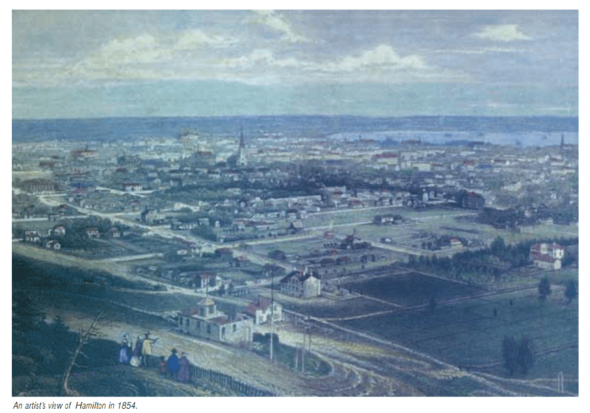
Figure 1
On top of contending with the ills of high-density housing, the working-class and poor lived nearest to the industries surrounding the wharves of Hamilton Port. An illustration produced in the first years of the 1900s (Figure 2) shows the expansiveness of the industrial presence along one portion of the Hamilton harbour.23 In the illustration, it is challenging for the viewer to see beyond the imposing industrial buildings and the billowing evidence of heavy industrial production. Living in the shadows of industrial smokestacks and the ever-expanding commercial activities of the port were further variables negatively affecting the quality of life for residents living closest to these areas. The illustrator captures the industrial waterfront at the beginning of the 1900s and shows the seamless transition from industry to residential housing that existed in the immediate area of Hamilton Port.
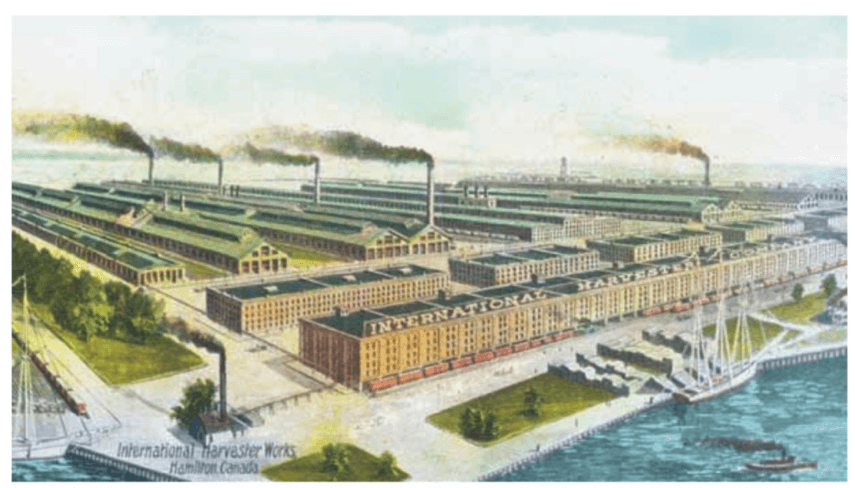
Figure 2
If residents wanted to escape the negative effects of living near the industrial activities along the waterfront, they could not take refuge in the city’s core. As mentioned, working-class and poor families were the primary residents populating the city’s core. However, living in the heart of the city, around the King Street and James Street area, had its own perils. Heavy industries, such as foundries and coachworks, were in the center of the city; these were the largest, dirtiest, and most dangerous factories to work at or live by in Hamilton (see Figure 3).24 Contrary to standard 19th-century city planning practices used in the development of most other Canadian commercial centers, Hamilton city planners positioned heavy industry in the city’s core. Although this strategy worked for planning the city of Hamilton, urban development historians consider the example of Hamilton as an anomaly.25
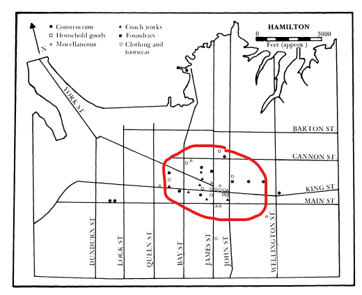
Figure 3: Concentration of industries employing more than five workers (King and James Streets), 1853.
Rapid economic development and intense urbanization of the geographical area surrounding Hamilton Port were observed throughout the second half of the 19th century. Because of intense economic and social growth, environmental conditions in the immediate area and the subsequent health of its residents suffered. Poor drinking water plagued the city’s poorest areas and was partially resolved in the 1850s with the opening of the Hamilton Waterworks.26 However, even after the opening of the Waterworks, environmental degradation of the port and its surrounding lands and waters continued. Fish stocks continued to decline, and the fishing industry was on the precipice of collapse. A government fisheries inspector raised concerns in the 1860s when he found that fish taken from the waters of the Sherman Inlet smelled and tasted like coal oil.27 The relentless dumping of industrial and residential waste into the water and along the southern shoreline transformed the harbour, creating areas that were unsafe, unusable, and unrecognizable from their former natural beauty.28 Inadequate sewage infrastructure to accommodate the rapid expansion of urbanization and industrialization around the Hamilton Port resulted in a myriad of health concerns, especially for residents in congested inner-city housing. Construction on the city’s sewer system began in the 1850s; however, two decades later only ten percent of Hamilton’s houses were serviced by sewers.29 Not surprisingly, the upper class benefitted first from a functional sewer system years before the sewers reached the poorer sections of the city.
It is notable that environmental and public health issues were geographically clustered in areas of the city primarily populated by poor and working-class families. Streets bordering the immediate vicinity of the port areas housed working-class and poor families. Housing units in the inner city were hastily constructed, poorly maintained, and tended to be rental properties housing multiple families in overcrowded and challenging circumstances (see Figure 4).30 The concentration of poor and working-class families in these spaces created neighbourhoods that the city’s upper-class elites seldom visited out of fear for their well-being and safety.31
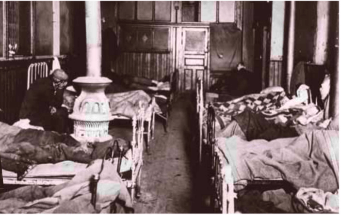
Figure 4: Multiple families residing in the inner-city
Although working-class, middle-class, and upper-class Hamiltonians might be found residing on the same street, this was an exception and was not the ‘norm.’ Neighbourhoods near the port were most often characterized by homogeneous traits, with class and ethnicity serving as the primary gatekeepers.32 As a result, most landowners, business executives, and political elites lived in distinct districts, separate from streets and communities occupied by working-class and economically challenged families. For example, the south end of the city was characterized by large estates; this area consisted of approximately 346 acres nestling up to the escarpment and far from the overcrowded King and James Streets area (see Figure 5).33 Members of the upper-class and political elites lived in areas devoid of unattractive terrain; their houses were large, well-constructed, elaborately appointed with more than the basic amenities, and located far away from the industrial pollution and overcrowded inner-city dwellings characterizing the areas near the port and its extensive and expanding industrial footprint.34
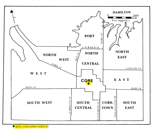
Figure 5: Hamilton’s core (King and James Streets) and sub-areas
Conclusions: A City of Contrasts
There is little doubt that the Hamilton Port was a primary catalyst for the economic prosperity, industrial and commercial growth, and increased social development of Hamilton in the 19th century. Without the introduction of the port, Hamilton would have likely struggled as an emerging settlement. However, historical evidence discussed above suggests that an individual’s class identity was instrumental in organizing their health outcomes, living conditions, and overall quality of life. Those who worked on the wharves loading and unloading cargo were unskilled labourers, and they struggled economically to avoid poverty and its reduced quality of life. Although there were heterogeneous neighbourhoods, most of Hamilton’s living areas were divided into those who were wealthy and those who were not. The conveniences of basic necessities, such as clean and running water and sewer systems were slow to come to the working and lower class neighbourhoods.
The port’s economic success was in part driven by the labour of those working on the wharves and in the city’s industrial and commercial enterprises that flowed through the port. However, the divide between the wealthy and poor increased in the 19th century, despite the prosperity attributed to the city. Residents in the city’s inner core found themselves living in the middle of heavy industries such as foundries and carriage works; the placement of these heavy industries in the center of the city meant that residents lived close to their industrial neighbours. The dumping of industrial waste along the waterfront and the infilling of marshlands with “clean” garbage to build housing upon created a health hazard for its residents. Again, the majority of those adversely affected by industrial, commercial, and residential waste dumping were working-class and poor families.
The economic and social development of Hamilton throughout the 19th century was fueled by its port. However, the prosperity experienced by business owners, landowners, politicians, professionals, and members of the upper class far exceeded any gains experienced by most working-class and poor families. Considering the historical evidence presented throughout the paper, it is evident that Hamilton was a city of contrast in the 19th century. One of the challenges in charting the experiences of the poor and marginalized unskilled workers is the elevated level of transiency amongst those in precarious employment. Semi-skilled and unskilled labourers tended to migrate, following employment leads in other cities, as Hamilton businesses opened and closed throughout the 19th century; this employment trend can obscure actual levels of unemployment and poverty depending on businesses’ boom and bust cycles. Hence, Hamilton as a city of contrast may understate the contrast between working-class and poor families with their upper-class counterparts.
Future research might consider whether the development of Hamilton Port in the 19th century could have been more equitable for all stakeholders. Integral to such an investigation would be examining the role labour unions played in bolstering the working and living conditions of workers and their families. Other missing narratives to consider when researching the history of Hamilton Port include lived realities organized through discourses of race, ethnicity, gender, and Indigeneity. In addition, other ports on the Great Lakes provide insights into the overall development of ports. Were the experiences at Hamilton Port unique? Certainly, the planning of the city’s inner core was unique to industrial cities. Examining the histories of other Great Lakes ports is a critical piece to fully understand the organizing effects of how an individual’s class identity can determine their lived experiences, and Hamilton Port is no exception.
Appendix A
Percentages of poor and well-to-do residents by occupation

Source: Michael B Katz, _The people of Hamilton, Canada West: Family and class in a mid-nineteenth-century city_ (Cambridge: Harvard University Press, 1975), 72.
Appendix B
Percentages of home ownership by occupation

Source: Michael B Katz, _The people of Hamilton, Canada West: Family and class in a mid-nineteenth-century city_ (Cambridge: Harvard University Press, 1975), 82.
Appendix C
Diagram of Hamilton’s wharves in 1874

Source: Ivan, S. Brookes, _MacKay’s Wharf: The story of a shipowning enterprise in Hamilton_ (1989), 7.
-
Sarah Palmer, “Histories of the ports,” International Journal of Maritime History 32, no. 2 (2020): 426–433. Doi: 10.1177/0843871420921266; Also see Adrian Jarvis, “Port History: Some Thoughts on Where it Came from and Where it Might be Going,” in Lewis R. Fischer and Adrian (Editors), Research in Maritime History Harbours and Havens: essays in Port History in Honour of Gordon Jackson (International Maritime Economic History Association, St. John’s Newfoundland, 1999): 13-34. ↩
-
Michael Katz, The people of Hamilton, Canada West: Family and class in a mid-nineteenth-century city (Cambridge: Harvard University Press, 1975). ↩
-
Edward M. Hodder, The Harbours and Ports of Lake Ontario: In a Series of Charts, Accompanied by a Description of Each, Together with the Lighthouses, Harbour Lights, Depth of Water, Courses and Distances Compiled from Authentic Sources, the Charts of Captain Owen and Lieut. Herbert, from Recent Surveys, as Well as from Personal Observations (Toronto: Maclear, 1857). ↩
-
Ivan S. Brookes, Hamilton Harbour 1826–1901: a transcription for the Maritime History of the Great Lakes by Walter Lewis (Halton Hills: Maritime History of the Great Lakes 2001), Chapter 1, para. 4. ↩
-
Brookes, Hamilton Harbour 1826–1901, Chapter 2, para. 2 – 5. ↩
-
Brookes, Hamilton Harbour 1826–1901. Chapter 2, para. 6 – 8. ↩
-
Ken Cruikshank and Nancy Bouchier, “Blighted areas and obnoxious industries: Constructing environmental inequality on an industrial waterfront, Hamilton, Ontario, 1890-1960,” Environmental History 9, no. 3 (July 2004). ↩
-
Cruikshank and Bouchier, “Blighted areas and obnoxious industries.” ↩
-
Katz, The People of Hamilton, Canada West, 72. ↩
-
Katz, The People of Hamilton, Canada West, 72. ↩
-
Katz, The People of Hamilton, Canada West, 72. ↩
-
Katz, The People of Hamilton, Canada West, 72. ↩
-
Katz, The People of Hamilton, Canada West, 72. ↩
-
Palmer, “Histories of the ports,” 427. ↩
-
Ian Davey and Michael Doucet, “The social geography of a commercial city, ca., 1853,” 323-324. ↩
-
Cruikshank and Bouchier, “Blighted areas and obnoxious industries,”470. ↩
-
Cruikshank and Bouchier. “Blighted areas and obnoxious industries,” 470. ↩
-
Cruikshank and Bouchier. “Blighted areas and obnoxious industries,” 470. ↩
-
Cruikshank and Bouchier. “Blighted areas and obnoxious industries,” 470. ↩
-
Davey and Doucet, “The social geography of a commercial city, ca., 1853,” 323. ↩
-
Davey and Doucet, “The social geography of a commercial city, ca., 1853,” 326. ↩
-
Figure 1: Bill Freeman, Hamilton: A people’s history (Toronto: J. Lorimer, 2001), 48. ↩
-
Figure 2: Freeman, Hamilton: A people’s history, 85. ↩
-
Davey and Doucet, “The social geography of a commercial city, ca., 1853,” 327; Figure 3: Ian Davey and Michael Doucet, “Appendix One: The social geography of a commercial city, ca. 1853,” in Michael Katz, The People of Hamilton, Canada West: Family and class in a mid-nineteenth-century city (Cambridge: Harvard University Press, 1975), 335. ↩
-
Ian Davey and Michael Doucet, “The social geography of a commercial city, ca., 1853.” p. 327. ↩
-
Cruikshank and Bouchier, “Blighted areas and obnoxious industries,” 468. ↩
-
Cruikshank and Bouchier, “Blighted areas and obnoxious industries,” 468. ↩
-
Cruikshank and Bouchier, “Blighted areas and obnoxious industries,” 468. ↩
-
Cruikshank and Bouchier, “Blighted areas and obnoxious industries,” 470. ↩
-
Figure 4: Freeman, Hamilton: A people’s history, 85. ↩
-
Cruikshank and Bouchier, “Blighted areas and obnoxious industries.” ↩
-
Cruikshank and Bouchier, “Blighted areas and obnoxious industries.” ↩
-
Davey and Doucet, “The social geography of a commercial city, ca., 1853,” 323, 327; Figure 5: Davey and Doucet, “The social geography of a commercial city, ca., 1853,” 335. ↩
-
Cruikshank and Bouchier, “Blighted areas and obnoxious industries,” 468. ↩