20th Century Piers and Wharves
Industrial Development of Piers and Wharfs in Hamilton Harbour during the 20th Century and the Environmental and Public Impacts
Liam Knox
Hamilton - 2022
Hamilton Harbour is an invaluable part of the city of Hamilton. Throughout history to modern day, it has served a vital role to the economy and development of the city and its surrounding area. When Ontarians think of the city of Hamilton, the vision of the busy bay and countless industrial buildings may come to mind. This vision of the harbour is justified by the vast amount of Ontario goods that move through the bay, amounting to nearly two billion dollars each year.1 Additionally, the port’s industrial power is further demonstrated by the 620 acres of Hamilton waterfront used for commercial, recreational, and industrial purposes.2 However, the many piers and wharfs of Hamilton Harbour are what link the industrial presence of the city with the bustling atmosphere of the bay. In this busy location, lake commerce meets land industry. Although similar, piers and wharfs serve different roles in a port setting, and have different structures designed to suit their purposes. Modern piers are categorized by their role in recreational activities such as boating and fishing, and thus jut out straight into the water. Wharfs on the other hand serve a largely industrial role and run horizontally with the shore for easier ship docking and loading. Today, 28 piers exist that serve a variety of purposes, and 15 wharfs that have a commercial purpose, further solidifying their importance to Hamilton’s waterfront.3
Although initially established prior to the twentieth century, the harbour endured a vast amount of development during the 20th century. This essay will analyze how the bay changed between the years 1919-1967 and how the events of World War II sparked industrial change in the port. Moving into the later years of the 20th century, the bay experienced important policy changes and new social and environmental issues that helped shape the development of the harbour. Therefore, this essay will also discuss the physical changes that occurred in the bay during the 20th century as well as analyze the public and environmental impacts of the industrialization of Hamilton Harbour. By analyzing aerial photographs from the 20th century and a multitude of secondary sources, this essay will argue that the physical changes in the harbour’s landscape, impacts of the piers and wharfs on both the bay and city atmosphere, public outlook, and environmental policies are all directly related to the war years and to Hamilton’s ongoing development, particularly as an industrial city.
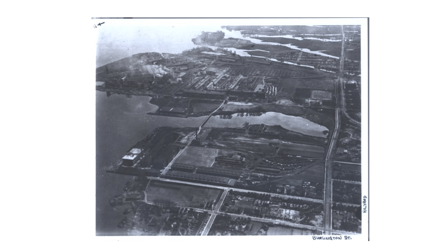
Figure 1: Aerial view of Hamilton's industrial sector north of Burlington Street, 1919
Photographs can be a useful tool when studying a change in geography or landscape over time. Fortunately, there are countless aerial photos of Hamilton Harbour, and the greater Hamilton area from the years 1919-1967. These photos have been divided into two groups for simplicity, photos taken prior to World War II, and photos taken after the war. When combined, the 1919 and 1934 photos reveal that Hamilton Harbour had already begun the industrialization process. In these aerial photos, industrialization is evident by the numerous warehouses, industrial buildings, and the large plumes of smoke rising from the stacks (see Figures 1 and 2).4 However, upon further examination of the 1934 photos (Figures 2 and 3), there is a noticeably a lack of large and distinguishable piers and wharfs that exist in Hamilton today.5 Although Hamilton had become an industrial powerhouse on Lake Ontario due to earlier business establishments in the years 1890-1910, and its strategic
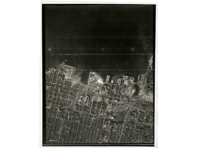
Figure 2: Eastern section of Burlington Bay, featuring the Skyway, 1934
location on the lake, the city had yet to construct any major piers or wharfs by 1934.6 Figure 3 (1934) and Figure 4 (1950) both capture the same area of land but the 1950 photo shows the establishment of piers and wharfs.7 Thus, there was evidently a large amount of development conducted on the piers and wharfs in the bay during the 16 years between 1934 and 1950.
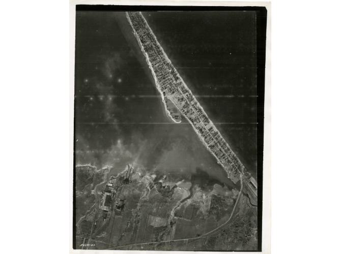
Figure 3: An aerial shot of the western portion of the harbour where Piers 10-15 would be built, 1934
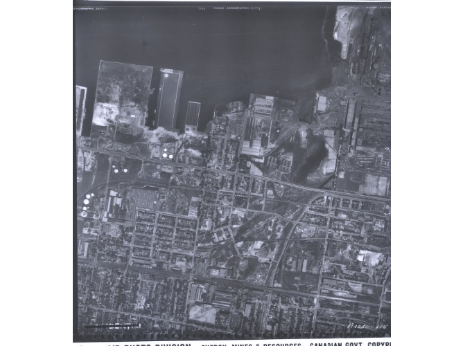
Figure 4: Same location as Figure 3, but note the difference in pier development between the two photos, 1950
During these 16 years of industrial development, World War II was simultaneously occurring in Europe. When war time came, Hamilton was called upon due to its existing warehouses and countless industrial plants.8 The city expanded many of its operations to suit the needs of the military, or constructed new facilities just to fuel the war effort.9 Steel-producing plants were converted to make munitions and artillery shells, while automotive factories were transformed to build parts for military vehicles.10 The port’s existing infrastructure, paired with Hamilton’s hard-working and proud civilians led to Hamilton playing a vital role in the production of naval military equipment and munitions.11 From the years 1939-1945 Hamilton’s population exploded from approximately 155,000 to 174,000, solely due to the influx of workers moving into the city during war-time.12 Therefore, although Hamilton had previously established itself as an economic and industrial powerhouse that rivalled Montreal and Toronto, it had yet to expand its facilities and plant itself in economical markets.13 During World War II, Hamilton experienced further developments such as larger piers and wharfs in the bay, an increase of industrial buildings and smoke stacks, and accommodating larger cargo ships so that they could dock on the wharfs.14 World War II fueled industrial expansion in the harbour, as the piers and wharfs transformed to meet the rising military needs. Hamilton Harbour experienced dramatic changes to the ports and wharfs in order to fuel the war effort, which in turn would boost its industrial prominence in the post-war years.
By analyzing the post-war photos, it is evident that the industrial transformation of the bay continued long after WWII. When the war ended, steel companies and private industries were quick to plant their feet in the economy.15 Providing for the military during war time also proved to be very lucrative for the businesses and plants in Hamilton, and thus provided the means to successfully expand their production and place themselves in post-war markets.16 Figures 4-6 display an increased number of industrial buildings, but more importantly they show that warehouses and factories continued to be built closer to the water and on top of the newly made piers and wharfs.17 In these images, the smokestacks were also more prevalent and display smog clouds similar to what a driver may see as they cross the bay on the QEW.18 Transportation opportunities vastly increased and became more efficient. Cargo ships in the lake could dock along the 8,400 meters of dock-walls and wharfs or sit in the bay.19 The harbour had access to two class-1 train rails that ran along the lake and into the port, and had connections to the 400 series highway.20 Today, Hamilton Harbour is home to a
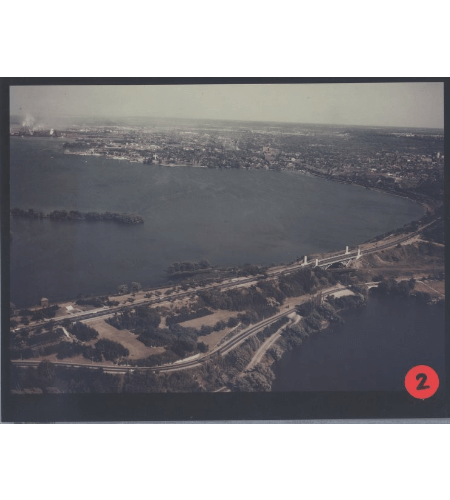
Figure 5: A view of the western piers in the bay from the northwest
pproximately 130 different companies.21 Under the Canada Marine Act of 1998, The Canadian Port Authorities (CPA) have deemed the Hamilton port as one of 18 Canadian ports vital to international and domestic trade, and the Canadian economy as a whole.22 Overall, from its industrial beginnings at the turn of the eighteenth century, the port had very few piers or wharfs, and they were barely developed. However, at the beginning of war, the port underwent a drastic new development constructing the many piers and wharfs that exist today. In the 21st century, the lake port remains an industrial and economic powerhouse that is constantly evolving.

Figure 6: An aerial view of portions of the major Defasco piers and wharfs in development
Despite the numerous advantages of being an industrial powerhouse, such as the access to transportation, there are two apparent issues that arise out the industrial transformation. One of these issues concerns the public and recreational use of the port despite its industrial concentration. As Wakefield notes, the public feelings towards industrial sectors has changed from a prideful and positive emotion as expressed during the industrial era, to a more run-down and negative outlook.23 Many modern industrial based cities have been presented with the problem of having to shed a positive light on their industrial sectors.24 These processes often involve attempts to “revive” the waterfront and transform it to better suit public needs.25 The hope is that by transforming the waterfront into something useable by the public, it may generate a more positive social worth towards the industrial areas. However, because Hamilton is so incredibly industrial focused, it presents a unique challenge for city planners and policy makers. In fact, it is so industrial that by 1990 less than 5% of the Hamilton waterfront was reserved for public use, but by 2006 that had risen to nearly 25%.26 The solution to this problem would be to allow more public access to the Hamilton shore. Yet, because of Hamilton’s economic reliance on their waterfront companies (especially major steel companies such as Stelco and ArcelorMittal Dofasco), there is a unique dichotomy that involves creating a more community friendly waterfront, while maintaining the economic power of the piers and wharfs.27
Within her article, Wakefield also examines the Hamilton Harbour Waterfront Trail which spans along the industrial shores of Hamilton. As part of the revitalization process, the trail does not avoid the industrial sector, but rather incorporates the commercial piers and wharfs, along with other public attractions along the shore.28 By revitalizing the trail, the city and the Hamilton Port Authority (HPA) hope to encourage public use and recreation along the waterfront, thus improving the public’s perceptions of the heavily industrialized sectors. In addition, the port authorities transferred ownership of both piers 7 and 8 to the city to be used by the public, which in turn aided the redevelopment process of the waterfront.29 In 2017, The HPA devised a Land Use Plan in order to explain their plans for a sustainable future in the port.30 In this outline, the HPA discusses every pier in the harbour and explains the policies they have planned to set in place regarding land use, transportation, environmental, and public realm contexts.31 It is clear that the public’s attitude towards the industrial sectors of Hamilton plays a critical role in the future development of the piers and wharfs. Further, there is clearly a very thin line between maintaining the commercial prosperity of Hamilton, and gaining the public’s approval towards the industrial sectors, in which the piers and wharfs play an important role.
The second issue that arises from the industrial focus of the city of Hamilton is regarding the environmental status of the bay and shore. Like many industrial era developments, there was a tremendous focus on creating the most efficient and powerful technology for commerce, with very little room set for environmental caution. Currently, the harbour is in mixed state, with the eastern shores remaining the industry center, and the western harbourfront experiencing both public and private use.32 However, with a shift in focus from industrial powerhouses to environmentally conscious cities nearing the end of the 20th century, public attitude towards industry has also changed.33 As Wakefield highlights, there are new negative connotations that derive from the word industry, and much of this new meaning stems from the industry’s power to destroy the environment.34 As previously mentioned, cities in our modern time are modifying redevelopment plans to change the public attitude toward industrial sectors, and many of these plans include improving the health of the environment. For example, the HPA’s Land Use Plan has designed policy change and action towards improving the environmental health of every pier in the harbour.35 Their plans include adding greenspaces to existing piers, stormwater management, decontamination actions such as the Randle Reef Sediment Remediation project, introduction of natural gas energy, paving improvements, and many more projects and policies.36 Thus, both the HPA and the city government is working actively to change the environmental impacts of the harbour, and this starts with the piers and wharfs that dominate the shore. It can be concluded that throughout the 20th century, the industrial developments destroyed much of the ecology of Burlington Bay, but with a change of principles in the 21st century, it is safe to assume that all future development on the piers will carefully consider and prioritize its environmental impacts.
In conclusion, the piers and wharfs of Hamilton Harbour endured constant development throughout the 20th century. Beginning with the establishments of industrial sectors and businesses at the turn of the 19th century, Hamilton vied with great Canadian cities such as Toronto and Montreal for economic power. The port further evolved in the 15 years from 1935 until 1950 during World War II, when the city of Hamilton took on a vital role in fueling the war effort, which expanded its factories and production. In the post-war years, a visible expansion in the physical layout of the piers demonstrated the profitable gains of supporting the war effort and allowed Hamilton to establish itself in the post-war economy. Nevertheless, despite its economic surplus, the industrial era of Hamilton’s waterfront and the modern change in industrial outlook has given rise to new issues for the city. Like many other cities, the industrial power that once fueled public morale now holds negative connotations and a poor public mindset. This unfavourable outlook of industry required Hamilton to develop their piers to fit the needs of the public and allow for new recreational opportunities. Finally, the industrial wealth earned through most of the 19th century was made with little or no regard for the health of the environment. With a modern positive outlook on the environment and public support for change, the city of Hamilton has developed new policies and future strategies to improve the environmental health of the bay. Hamilton is unique in the fact that its economy still heavily relies on business that is decades old. The city must achieve and maintain a balance between preserving its industry and improving public outlook of its private sectors. Future developments in Hamilton Harbour that support the coexistence of commerce, leisure, and industry are crucial and present a unique challenge for policy makers and city planners. Studying the historical significance of piers and wharfs in the 20th century provides the rare opportunity to better aid those attempting to tackle this challenge. Piers and wharfs play a crucial role in the industry of Hamilton, as it is important to study patterns from the past in order to make informed decisions about moving forward with environmental, public, and industrial initiatives.
-
Hamilton Port Authority, “Hamilton’s Working Waterfront Port of Hamilton Land Use Plan,” (October 2017), 19, https://www.hopaports.ca/wp-content/uploads/2017/11/HPA-Land-Use-Plan-FINAL-October-2017.pdf. ↩
-
Hamilton Port Authority, “Working Waterfront,” 3. ↩
-
Hamilton Port Authority, “Working Waterfront,” 3. ↩
-
Figure 1: “City of Hamilton,” photo S5836, McMaster University’s Digital Archive, 1919, https://digitalarchive.mcmaster.ca/islandora/object/macrepo%3A71644; Figure 2: “Greater Hamilton Area, from Caledonia to Vineland,” Flightline A4871-Photo 20, McMaster University’s Digital Archive, 1934, https://digitalarchive.mcmaster.ca/islandora/object/macrepo%3A71945. ↩
-
Figure 3: “Greater Hamilton Area, from Caledonia to Vineland,” Flightline A4871-Photo 16, McMaster University’s Digital Archive, 1934, https://digitalarchive.mcmaster.ca/islandora/object/macrepo%3A71892. ↩
-
Diana J. Middleton and David F. Walker, “Manufacturers and Industrial Development Policy in Hamilton, 1890-1910,” Urban History Review 8, no. 3 (1980): 21, https://doi.org/10.7202/1019361ar; ↩
-
Chris Madsen, “Industrial Hamilton's Contribution to the Naval War,” The Northern Mariner 16, no. 1 (January 2006): 51, https://www.cnrs-scrn.org/northern_mariner/vol16/tnm_16_1-21-52.pdf; Figure 4: “Hamilton Area,” Flightline A12511- Photo 115, McMaster University’s Digital Archive, 1950, https://digitalarchive.mcmaster.ca/islandora/object/macrepo%3A72261. ↩
-
Madsen, Naval War, 24-25. ↩
-
Madsen, Naval War, 24-25. ↩
-
“Canada and the War, Life on the Homefront: Hamilton, Ontario, a City at War,” Canadian War Museum, accessed January 25, 2022. https://www.warmuseum.ca/cwm/exhibitions/newspapers/canadawar/hamilton_e.html. ↩
-
Madsen, Naval War, 24-25. ↩
-
“Life on the Homefront.” ↩
-
Middleton, and Walker, “Industrial Development,” 20-21; Madsen, Naval War, 23. ↩
-
Figure 3 & 4. ↩
-
Madsen, Naval War, 52. ↩
-
Madsen, Naval War, 38. ↩
-
Figure 5: “Views of Hamilton from the northwest,” photo C241, McMaster University’s Digital Archive, Northway-Gestalt Corporation, 1955, https://digitalarchive.mcmaster.ca/islandora/object/macrepo%3A71397; Figure 6: “City of Hamilton,” Flightline J2620-Photo 52, McMaster University’s Digital Archive, 1964, https://digitalarchive.mcmaster.ca/islandora/object/macrepo%3A80950. ↩
-
Hamilton Port Authority, “Working Waterfront,” 15. ↩
-
Hamilton Port Authority, “Working Waterfront,” 38, 61. ↩
-
Hamilton Port Authority, “Working Waterfront,” 12. ↩
-
Hamilton Port Authority, “Working Waterfront,” 2. ↩
-
Sarah Wakefield, “Great Expectations: Waterfront Redevelopment and the Hamilton Harbour Waterfront Trail,” Cities 24, no. 4 (2007): 298, https://doi.org/10.1016/j.cities.2006.11.001. ↩
-
Wakefield, “Great Expectations,” 298. ↩
-
Wakefield, “Great Expectations,” 300-301. ↩
-
Wakefield, Great Expectations, 299. ↩
-
Hamilton Port Authority, “Working Waterfront,” 16; Wakefield, “Great Expectations,” 298. ↩
-
Wakefield, “Great Expectations,” 298-308. ↩
-
Wakefield, “Great Expectations,” 302-305. ↩
-
Hamilton Port Authority, “Working Waterfront,” 17. ↩
-
Hamilton Port Authority, “Working Waterfront.” ↩
-
Hamilton Port Authority, “Working Waterfront,” 25-54. ↩
-
Wakefield, “Great Expectations,” 299-306. ↩
-
Wakefield, “Great Expectations,” 298. ↩
-
Wakefield, “Great Expectations,” 298. ↩
-
Hamilton Port Authority, “Working Waterfront,” 25-54. ↩
-
Hamilton Port Authority, “Working Waterfront,” 12. ↩