Treaties and Tensions
Colonial Land Rights in Hamilton Harbour
Leah Brown
Hamilton - 2022
Hamilton Harbour, formerly known as Burlington Bay, has been an important environment in the lives of the Mississaugas people for centuries. The Mississaugas also known as the Mississaugas of the New Credit First Nation (MNCFN) are part of the Ojibwa (Anishinaabe) Nation and are historically referred to by either name interchangeably.1 This group established themselves along the north shores of Lake Ontario between 1700 and 1720 and relied heavily on the area’s waterways.2 The Bay had an abundance of wildlife and fish which sustained the Mississaugas and played an immense role in their day-to-day lives. By reviewing the historical development of the lesser documented treaties, land purchases, and waterway claims, this paper will analyze how these established treaties impacted the MNCFN and how they altered the landscape and settlement patterns. The colonial land rights surrounding the Burlington Bay area, significantly affected the traditional way of life for the MNCFN, particularly threatening their access to resources such as food and waterways and, to some degree, threatening their defense against the large influx of settlers prior to their relocation in 1847.3
Burlington Bay has been known by many different names, some names given by Indigenous peoples and others by immigrating settlers.4 The Bay is located on the western point of Lake Ontario but is naturally separated by a sand bar.5 It has been described as a beautiful landscape with an abundance of fish, wildlife, and a vast beach shoreline that was created by the northeast wind and currents of Lake Ontario depositing large amounts of sand and debris onto the shore.6 Over time, Burlington Bay has physically changed in many ways, particularly as the area continued to experience an influx of settlers, significantly impacting the present-day Bay environment.7
In the precolonial period, the MNCFN occupied territory inland from the shores of Lake Huron. Their life was centered around wildlife, particularly fishing and hunting which involved moving where the food and natural resources were available. The Mississaugas’ specific location depended on the seasons and months of the year.8 The winter months included hunting for small game and ice fishing, whereas the early fall was focused on the harvest of crops such as squash, corn, beans.9 Even though the MNCFN covered such a large territory, there were no fixed boundaries and resources were shared communally.10
Despite this communal aspect, hostilities with other Indigenous groups was one factor that caused the MNCFN peoples to move closer to the Burlington Bay, demonstrating the variety and diversity of Indigenous groups within this area. In the 1650s, there were many large-scale attacks on MNCFN communities for land and access to resources.11 The attacks were instigated by the Iroquois as they destroyed crops, livestock, and the homes of smaller Indigenous communities which forced these communities to relocate elsewhere. By the end of the 1650s, the Five Nation Iroquois had obtained a large portion of territory and threatened the 1650 location of the MNCFN/Anishinaabe on Lake Huron. After many battles and negotiations, the MNCFN settled permanently southeast of Lake Huron12 giving them access to a large territory in and around Lake Huron, Lake Erie, and specifically Burlington Bay. A primary camping ground of the Mississaugas was known as the mouth of the Credit River (Missinnihe). After the defeat of the Iroquois and relocation of Hurons peoples, the entire area once controlled by the Iroquois was now inhabited by the Ojibwe.13 The Ojibwe peoples that moved along their land toward the Credit River became known as the “Mississauga Indians,” a name coined by the French.14 Although many Ojibwe remained near Lake Huron and the Georgian Bay area, many traveled to the southeast lands of Upper Canada (MNCFN). The constant movement and greater inhabited land space during this period made the Ojibwe, particularly the MNCFN, closer to and more influenced by European contact/settlement.15
Reviewing the historical development of treaty-making during the influx of settlers, paints a more precise picture of Burlington Bay and how it became known as such. The treaties created in Ontario are legal land agreements that outline the responsibilities and legal rights of Indigenous peoples and the British Crown. The “Between the Lakes Purchase,” later referred to as Treaty 3, was signed December 7th, 1792.16 Treaty 3 was used to clarify the previous “Between the Lakes Purchase” that was originally signed in 1784, covering approximately 3 million acres of land between Lake Ontario and Lake Erie.17 This treaty was signed to ensure Indigenous peoples and settler populations could coexist and share resources, and secured the Mississauga peoples’ right to hunting and fishing on the reserve lands.18 The map below (Figure 1) outlines Treaty 3 in purple and also highlights the space shared between the MNCFN and the Six Nations during this time, as distinguished within the blue triangle.19
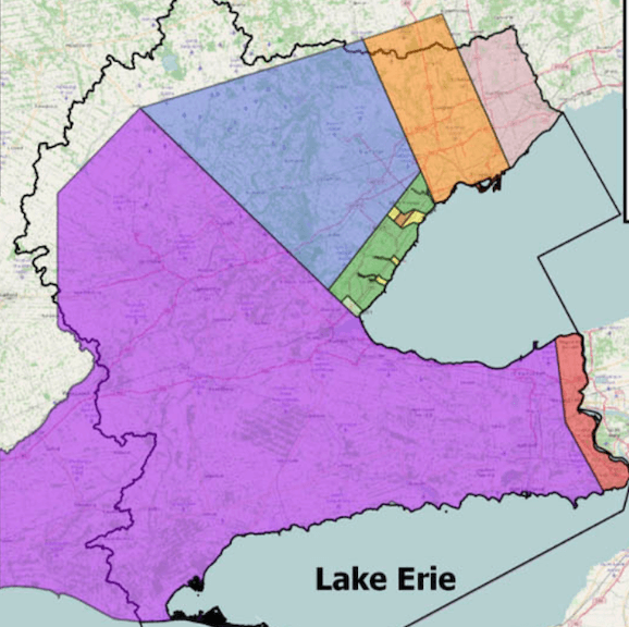
Figure 1: Map outlining multiple treaties signed by the MNCFN
While treaties are formal land agreements on paper, Indigenous peoples often interpreted treaties and land agreements differently than the British Crown did, particularly if there were oral promises made prior to the treaties being signed that were not always fulfilled by the British Crown. The Mississaugas interpreted the treaty agreements in a different manner than the colonial government as the colonial government saw the land as a resource and something that could be ‘purchased’ once and owned forever.20 The Mississaugas had a spiritual connection to the land and resources, and thus the idea of “selling land” was not something they believed in. When they signed treaties, the MNCFN did so without understanding they would be unable to use and access the resources of the sold/surrendered land and that the land would no longer “belong to them”21 because this was often not communicated properly or honestly.
After the 1800s, the growing population of settlers put enormous pressure on the Mississauga peoples’ ability to live a normal traditional life.22 Their response involved seeking protection and rights to continue their traditional way of living in their territory without disruption. The Mississauga chiefs petitioned again for the colonial government to secure their rights to hunt and fish within the land that was surrendered in agreements/treaties.23 The petition put forward by the Mississauga peoples was disregarded and set aside and nothing was enacted at this time.24 On October 24th, 1795, a new treaty called the Brant Tract Treaty, also known as Treaty 3¾, was signed.25 Through this treaty, the British Crown purchased 3500 acres of land from the Mississauga peoples (see the red circle in Figure 1) which is said to have been purchased for the Mohawk Chief, Joseph Brant, as a thank you for his efforts in the American Revolutionary War.26 As higher influxes of settlers continued to immigrate to Canada, the colonial government continued to negotiate for more land, particularly the land that had access to resources such as creeks and rivers inland.27 Despite signing the treaties separately, the Six Nations and the Mississaugas of the Credit First Nation were connected in their treaty signing because their decision affected each other.
Treaty 19 was signed on October 28th, 1818. In this treaty, the MNCFN surrendered a portion of land to the Crown in exchange for annual goods since their resources continued to be threatened by the influx of settlers.28 This land was referred to as the “new survey” within Toronto. The Mississauga peoples were able to keep three portions of land on the Credit River which is also referred to as the Credit River Indian Reserve (see the red triangle in Figure 1). The portions included the Twelve Mile Creek and Sixteen Mile Creek which were retained before Treaty 13A.29 Shortly thereafter, this land was also surrendered on February 28th, 1820, through Treaties 22 and 23 (see Figure 2).30 In Treaty 22, the MNCFN surrendered all the land they possessed in modern-day Queensway to Lake Ontario and both Twelve Mile Creek and Sixteen Mile Creek.31 Treaty 23 was also signed on the 28th of February, and the land that was surrendered remained between the portions of acreage ceded in Treaty 22, and the land on both sides of modern-day Dundas Street.32
The signing of treaties 22 and 23 left the Mississauga Nations with only 200 acres of land on the east side of the Credit Indian Reserve/Credit River. The MNCFN continued to sign these treaties based on their own interpretation of what the treaties could provide, such as partnership and the ability to co-exist on the land, but in some cases, they were forced to sign them or there was an overall miscommunication, lack of honesty, and broken promises from the British Crown. The loss of so much land in a relatively brief period negatively impacted the MNCFN, and they felt as though the settlers were trying to remove them from their land entirely or relocate them to the parts of the land with the least amount of natural resources.33 In June of 1847, the Chief of the MNCFN relayed a statement of concern regarding the tracts of land.34 Chiefs Joseph Sawyer and Peter Jones noted that some portions of land had never been surrendered to the British Crown and argued that this land still belonged to the MNCFN.35 Although the Chiefs believed their claims would be respected, they were ignored.36

Figure 2: Map outlining Treaty 22 and Treaty 23
Treaties and land agreements were an intricate part of the lives of the MNCFN. When the British Crown created and signed treaties with the Mississauga peoples, their documented communication described that they wanted the land for settlement purposes.37 There was no indication that the lakes and rivers were attached to these agreements. It is evident that the Mississauga peoples opposed surrendering their traditional land regions and lakeshore, as the creeks and waterways were a crucial component of their way of life, particularly an important food source.38 Recognizing how important the waterways were to the MNCFN, the colonial government passed legislation at the beginning of the 19th century that reserved some fishing areas for the MNCFN and restricted on the number of fish that settlers were allowed to catch.39 However, these supports were not strictly enforced and the MNCFN continually submitted petitions declaring their ownership of the ‘ceded’ lands and their right to hunting and fishing grounds. They also requested the protection of waterways, creeks, and other resources within their traditional lands.40 On numerous occasions in 1850, the MNCFN chiefs recognized various surrendered reserves along waterways that fed into Lake Ontario and identified tracts of land along the lakeshore that had initially been reserved.41 The chiefs expressed their concern for hunting and fishing rights as well as their concerns for future generations not being able to use the land.42
Indigenous-colonial land rights around Burlington Bay influenced the lives of the MNCFN. They lost their traditional lands, hunting grounds, which made their traditional way of living and maintaining enough land for future generations very difficult.43 Between the 1700s and 1800s, the mass purchasing of land left a lasting impact on Indigenous communities and their ability to move with the seasons and follow food sources. The MNCFN continued to adapt their way of living and demonstrated resiliency as these changes occurred. The numerous treaties and immigration of settlers ultimately led to the relocation of the Mississauga peoples in 1847.44 They decided to establish a new settlement on the tract land in the southwest of the Six Nations Reserve. The Six Nations offered the MNCFN land for to rebuild their culture and lifestyle. This land was offered by the Six Nations because the Mississaugas had proven to be allies in times of need and support.45 There were several reasons for this relocation, one being that the Mississaugas peoples’ new settlement would be within the traditional territory of the historical MNCFN, and it was very close to their existing settlement on the Credit River.46 The MNCFN confirmed their settlement in 1903 and have remained settled there to this day.47 The history of Burlington Bay is just one example of how colonial immigration, land rights, and waterway agreements affected the MNCFN.48
The Burlington Bay (Hamilton Harbour) has been a significant area in the lives of Mississaugas of the New Credit First Nation (MNCFN) for centuries, as the land sustains life for current and future generations. The MNCFN had spiritual beliefs, traditional practices, and teachings that directly connected them to the earth and more specifically to the land and its resources. The loss of their land and waterways to the British Crown and the influx of European settlers negatively affected the MNCFN to the point of relocation. The historical review and revaluation of perspectives and treaties between settlers and the MNCFN is a very important and complex topic. By looking at less documented treaties, land purchases agreements, and waterway claims we can better understand how indigenous–colonial land rights around Burlington Bay influenced the lives of the Mississauga’s of the New Credit First Nation, particularly with the loss of land and broken treaty promises.
-
Praxis Research Associates, “The History of the Mississaugas of the New Credit First Nation,” (Hagersville, ON: Mississaugas of the New Credit First Nation), https://www.oakvillehistory.org/uploads/2/8/5/1/28516379/the-history-of-mncfn-final.pdf. ↩
-
Praxis Research Associates, “The History of the Mississaugas.” ↩
-
Joan Holmes Associates Inc., “Aboriginal Title Claim to Water Within the Traditional Lands of the Mississaugas of the New Credit,” for the Mississaugas of the New Credit (March 2015), http://mncfn.ca/wp-content/uploads/2017/02/MNC-Aboriginal-Title-Report.pdf. ↩
-
Mrs. John Rose Holden, Burlington Bay, Beach, and Heights, in History (Hamilton, ON: W. T. Lancefield, 1898), 9. ↩
-
Holden, Burlington Bay, 10. ↩
-
Holden, Burlington Bay, 10. ↩
-
Holden, Burlington Bay, 12. ↩
-
Joan Holmes Associates Inc., “Traditional Lands.” ↩
-
Joan Holmes Associates Inc., “Traditional Lands,” 30. ↩
-
Reneé Joy Goretsky, “Indigenizing Water Governance within Treaty Lands and Territory: Development of Mississaugas of the Credit First Nation Water Framework,” A Thesis presented to The University of Guelph (Reneé Goretsky, May, 2021), https://atrium.lib.uoguelph.ca/xmlui/bitstream/handle/10214/25714/Goretsky_Renee_202105_PhD.pdf?sequence=1&isAllowed=y. ↩
-
Praxis Research Associates, “The History of the Mississaugas.” ↩
-
Praxis Research Associates, “The History of the Mississaugas.” ↩
-
“Community Profile,” Mississaugas of the Credit First Nation, accessed March 2022,
-
“Community Profile.” ↩
-
Meaghan FitzGibbon, “The Mississaugas,” Heritage Mississauga, accessed March 2022, http://heritagemississauga.com/the-mississaugas. ↩
-
Government of Ontario, “Map of Ontario treaties and reserves,” Ministry of Indigenous Affairs, last modified January 13, 2022, https://www.ontario.ca/page/map-ontario-treaties-and-reserves. ↩
-
Government of Ontario, “Map of Ontario treaties and reserves.” ↩
-
FitzGibbon, “The Mississaugas.” ↩
-
Figure 1: Praxis Research Associates, “The History of the Mississaugas.” ↩
-
Elizabeth Kawenaa Montour, “Treaties with Indigenous peoples: past and present,” Library and Archives Canada Blog, posted on June 21, 2019, https://thediscoverblog.com/2019/06/21/treaties-with-indigenous-peoples-past-and-present/. ↩
-
Joan Holmes Associates Inc., “Traditional Lands.” ↩
-
Joan Holmes Associates Inc., “Traditional Lands.” ↩
-
Joan Holmes Associates Inc., “Traditional Lands,” 41-43. ↩
-
Joan Holmes Associates Inc., “Traditional Lands,” 53-56. ↩
-
Government of Ontario, “Map of Ontario treaties and reserves.” ↩
-
Government of Ontario, “Map of Ontario treaties and reserves”; A. Ellston Cooper, “That Chivalrous savage…Joseph Brant,” Maclean’s Magazine, January 15, 1954, https://archive.macleans.ca/article/1954/1/15/that-chivalrous-savage-joseph-brant. ↩
-
Government of Ontario, “Map of Ontario treaties and reserves.” ↩
-
Government of Ontario, “Map of Ontario treaties and reserves.” ↩
-
Government of Ontario, “Map of Ontario treaties and reserves.” ↩
-
Government of Canada, Indian Treaties and Surrenders: Treaties 1-138 (Fifth House Books, reprinted 1992); Figure 2: Praxis Research Associates, “The History of the Mississaugas.” ↩
-
FitzGibbon, “The Mississaugas.” ↩
-
FitzGibbon, “The Mississaugas.” ↩
-
Joan Holmes Associates Inc., “Traditional Lands.” ↩
-
Government of Canada, Indian Treaties and Surrenders. ↩
-
Joan Holmes Associates Inc., “Traditional Lands.” ↩
-
Joan Holmes Associates Inc., “Traditional Lands,” 51-56. ↩
-
Joan Holmes Associates Inc., “Traditional Lands,” 51-56. ↩
-
Praxis Research Associates, “The History of the Mississaugas.” ↩
-
Joan Holmes Associates Inc., “Traditional Lands.” ↩
-
Joan Holmes Associates Inc., “Traditional Lands.” ↩
-
Government of Ontario, “Map of Ontario treaties and reserves.” ↩
-
Joan Holmes Associates Inc., “Traditional Lands.”
Praxis Research Associates, “The History of the Mississaugas.”
Praxis Research Associates, “The History of the Mississaugas.” ↩
-
Praxis Research Associates, “The History of the Mississaugas.” ↩
-
Praxis Research Associates, “The History of the Mississaugas.” ↩
-
Praxis Research Associates, “The History of the Mississaugas.” ↩
-
Montour, “Treaties with Indigenous peoples.” ↩
-
Praxis Research Associates, “The History of the Mississaugas.” ↩
-
Government of Canada, Indian Treaties and Surrenders. ↩